Transoxiana 13
Agosto 2008
Index 13
ISSN 1666-7050

|
|
Transoxiana 13 |
Laboratory of Geoarchaeology, Institute of Geological
Sciences, Ministry of Education and Sciences, Kazakhstan
ispkz[@]nursat.kz // www.lgakz.org
Keywords: hydrogeology, groundwater devices, karez, Middle Ages, South Kazakhstan
ABSTRACT: In Kazakhstan, before the present article, only 3 lines of wells (called "karez", which in Persian means "water uplift") were known in the area of Sauran (Turkestan oasis) from historical accounts, topographic maps and archaeological surveys. They were considered isolated specimens imported from elsewhere during late medieval times. Only in the years 2002-2004 geoarchaeological and aerial surveys discovered several karez lines in other areas of the Turkestan oasis and, in an area of 20x20 km around Sauran, 261 karez lines developing for 124 km and numbering more than 9000 wells. The geological, hydrogeological and archaeological context of the karez systems have been studied, together with their mapping and classification, analysis of construction features and elaboration of their data base. A preliminary interpretation of the phenomenon suggests that "karez" are not "qanat" but an original construction based on a local traditional deep knowledge of groundwater dynamics that today have been forgotten. They are man-made springs causing the surface resurgence of water from shallow aquifers not by underground galleries (qanat) but by micro-artesian and gravity pressure. They are not the product of a qanat technology imported during the late Middle Ages, but rather a genial local invention that could have evolved from the end of 1st millennium AD as a development of the well-technology of mixed farming-pastoralist communities adapted to desert regions. A preliminary modeling suggests (and some preliminary surveys confirm) that karez must also be present in great number in other desert areas of the Karatau piedmonts, of Semirechie and of other regions of Central Asia (Tarim, Nuratau, Turkmenistan). The discovery has most probably economical significance for modern land reclamation in desert zones.
CONTENTS
1 - Background knowledge about the karez of the Turkestan oasis
2 - Geographical and hydrogeological features of the Tastaksai-Aksai-Maidantal (TAM) region
3 - Classification of the TAM karez: lines, systems, zones
4 - Construction features of the TAM karez
5 - Archaeological context of the TAM karez
6 - Conclusions
Bibliography
Figures
Groundwater systems consisting of series of aligned wells interconnected by underground galleries have been constructed on desertic sloping piedmonts for more than 2000 years in Middle East (where they are called "qanat") and during the last 1000 in Turkmenistan and Tarim (where they are called "karez"). They are still active today in Iran, Turkmenistan and Tarim.
Information about the existence of karez in the Turkestan oasis is given by the historical account of Wasifi and by the ethnographic account of Dingelshstedt; and a few karez lines are documented on Soviet topographic maps.
The XVI century Tadjik writer Makhmud Zainaddin Wasifi, in a passage of "Amazing Events", says that in around 1510 the Muslim sheikh Mir-Arab, religious leader in Bukhara under the Chebanids, offered to the town of Sauran, in the Turkestan oasis, 2 karez lines and a "charbag" (walled garden), "similar to nothing that people traveling all around the world had ever seen neither on land neither on sea" (Boldirev 1957 pp 167-168)1. Wasifi's account inspired the first archaeological research of the karez of the Turkestan oasis. In 1986-88, the archaeologist VA Groshev detected 3 karez lines north of the ruins of the medieval town of Sauran (where in reality there is a system of 8 lines) and excavated, down to 4 m, 2 wells (in reality 11) of one of the lines without finding any trace of underground galleries. He interpreted the 3 karez lines as part of the system quoted by Wasifi2 and, even though facing opposite evidence, didn't doubt of the presence of underground galleries and the similarity of the Sauran karez with the qanat of the Middle East. Together with Wasifi, the karez of Sauran were interpreted as an exotic rarity imported by an enlightened religious leader during the Late Middle ages.
The second important document (that apparently had not been recovered until now) about the existence of karez in the Turkestan oasis is represented by a few pages of an ethnographic report made in the 1889 by the Russian colonel N Dingelshstedt. Analyzing the irrigation systems of the Turkestan region, Dingelshstedt says that karez exist, had been built more than 250 years ago, and some of them have been continuously restored and are still active. He asserts the presence of 18 active karez systems scattered in several valleys throughout the region; and, following the verbal reports of the local population, quotes the presence of 80 abandoned karez lines in the Sauran region. Like Wasifi, he is astonished by the marvelous characteristics of the karez system and comments: "It is rare to meet such an excellent and convenient system for agriculture. In the area of Turkestan karez are partially functioning today" (Dingelshstedt 1889, pp 280-332).
Topographic maps of scale 1/100,000, produced by the cartographic centers of SSSR on the basis of aerial photography, mark the presence, in the Turkestan oasis, of 6-7 karez lines, all located in the Tastaksai-Aksai-Maidantal (TAM) basin; and topographic maps of scale 1/25,000 mark the presence of more than 30 lines in the TAM region and of just a few lines in other valleys. These topographic documents have been available since 1956 but evidently their analysis was not a standard methodological procedure for the archaeological experts of the time or for those of the following 50 years.
Accurate research about ancient groundwater devices in the Turkestan oasis was implemented during the years 2002-2004 by members of the Laboratory of Geoarchaeology of the Academy of Sciences of KZ,3 in cooperation with archaeologists of the Turkestan Archaeological Expedition (TAE),4 in the context of the INTAS project "Geo-archaeological investigations of land use and irrigation works in Kazakhstan in present and in historical times". Existing maps and aerial surveys proved to be particularly useful from the very beginning in helping the detection of a few karez lines in 5 valleys of the Turkestan oasis and of hundreds of lines in the basin of the Tastaksai, Aksai and Maidantal rivers (TAM) where the medieval town of Sauran is located. Where previous researche individuated just 3 very large tobe surrounded by ancient fields and farms [Karatobe (II-XIII AD), Sauran (XII-XVIII AD) and Mirtobe (XIV-XVI)] and 3 karez lines north of Sauran (all monuments already quoted in the 1:100,000 topographic maps), geoarchaeological surveys of a sub-rectangular area of 20x20 km, located between the Karatau piedmonts and the medieval town of Sauran, found an astonishing archaeological record. Here have been discovered, measured and mapped 7 other mid-size tobe, 104 isolated dwellings (Neolithic camps, Bronze Age, Early Iron Age and Medieval villages), Medieval agricultural fields, farms and canals and, most important, 261 lines of karez that all together sum a total development of 124 km with around 9,000 wells. Most probably these numbers will be increased of 10-15 % by future aerial and field-waking survey of the region5. The excavation by accurate methods down to 4 m of one of the wells of the most eastern of the 3 parallel karez lines reaching Sauran (karez 5.2.8) and the study of the profile of 2 wells exposed by erosion on the SE bank of the Maidantal river canyon (karez 7.3.3) didn't find any trace of underground galleries (Fig 7)
The progression of the research suggested a preliminary model of the karez phenomenon that guided subsequent strategies of investigation. The main hypothesis is that karez do not have artificial underground galleries, i.e. they are not qanat, but are in fact a more complex hydraulic device using a combination of several principles. The complexity of the hydrological principles goes together with the simplicity of the construction, which is realized by minimum labor investment and maximum knowledge and exploitation of natural conditions. The most important considerations supporting such interpretation are outlined here below.
A karez line is not intended, like a qanat, to transport, by gravity and underground galleries, groundwater from a localized aquifer downslope until emergence; but instead to raise by differential pressure the water table along the whole itinerary of the wells. Karez wells are not windows of underground galleries running on a (natural or artificial) impermeable layer (qanat); but, dug down into a water-bearing layer, are mouths through which groundwater is lifted to the surface by the interaction of 2 principles of water dynamics: hydrostatic pressure and gravity. Because they are dug into a shallow semi-confined aquifer having micro-artesian potential, the wells act as micro-artesian wells. Because they are aligned along a gentle slope and connected though natural horizontal strata of pebble deposits, they work by gravity as a sequence of connected vases making the water resurge from a certain point of the line, depending on the groundwater stock and the season.
So, for the functioning of a karez, the region must be endowed with 4 geological and hydrological preconditions:
The first condition provides the water recharge of the system, which in some cases is optimized by artificial devices such as large head-wells applied to the end of an ephemeral distributary (see below par 4.2f). The second and third conditions ensure the functioning of the principle of hydrostatic pressure. The fourth condition ensures the functioning of the principle of gravity. Given these preconditions, the 2 principles will be both active and will work complementarily in every karez line. Where the first principle of hydrostatic pressure is absent due to the poor impermeability of the first sedimentary layer or by no saturation of the second one, the karez system will anyway work by the second principle through gravity flow well-to-well along the pebble strata. The emphasis on the artesian effect favors the building of clusters of badly aligned wells intended to raise water in situ; the emphasis on the gravity effect favors the building of series of aligned wells intended to raise groundwater levels all along the line. The last case is the most common. (Fig 1)
The 4 preconditions discussed above are largely present in the Tastaksai-Aksai-Maidantal (TAM) basin, which constitutes the study polygon of the present communication.
The polygon under study consists of an area of 20x20 km located on the alluvial plain between the southern slopes of the Big Karatau mountains and the right bank of the middle course of the Syrdarya river. The plain of the polygon gently slopes south-south-west between 320 and 200 m asl with an average incline of 4/1,000 m (0.4%); and is crossed by the delta-like middle-low courses of 3 seasonal streams. It presents the typical desert landscape of the Northern Tienshan region, Karatau district (IV-A-41a), characterized by the light brown desert soils and shrub vegetation of semi-deserts with undulated relief. (Fig 2)
The territory of TAM is crossed by the distributaries (mostly dry) of the delta-like middle-low courses of 3 rivers, flowing north-south from the southern Karatau mountains towards the Syrdarya: the Tastaksai on the west, the Maidantal 10-12 km on the east; the Aksai between them. The Tastaksai river is 60 km long and ends just south-west of Sauran. The Maidantal river, 75 km long and the only one that occasionally reaches the Syrdarya, has the biggest surface and groundwater-flow and in fact produced the main geological fundament of the territory. The Aksai river, only 25 km long and ending in front of Karatobe, is by far the least relevant but, because of its central and depressed location, has the middle-low course water-fed by the convergence of some dry distributaries and of the groundwater of the 2 other streams. Apart from some segments of the main canyons of the Tastaksai and Maidantal that present at least a scanty permanent flow all year round, all the other river beds are either totally dry or intermittently active only during springtime. The mid-low courses of the 3 rivers have complex parallel, diverging and converging branches and, as a whole, constitute 3 deltas merging part of their groundwater and converging all together in the area of the old towns of Karatobe and Sauran.
Wet climatic phases occurring on a decennial and centennial scale can deeply change the hydrological conditions of the territory, determining much higher water regimes, floods and perennial marshes. The construction during Soviet times of 2 large reservoirs in the pre-mountain zone on the Tastaksai and Maidantal rivers reduced the hydrological and hydrogeological resources of the southern parts of the territory.
The main geomorphological features of the alluvial plain are determined by the characteristics of the distributaries of the 3 river deltas. They allow us to distinguish, from north to south, 3 altitudinal bands, which are also endowed with different hydrogeological features and have been concerned by specific water-use technologies (see below par 5.2).
These 3 altitudinal bands are most clearly pronounced along the Aksai river, where they correspond to its segments Karabulak, Aksai & Aksaikarez, Mirdinsai.
The geological structure of the centre of the TAM region (zone 4) consists of 225 m of alluvial (and partly aeolian) deposits of unconsolidated materials (clay, sand and pebble) accumulated on a substratum of consolidated chalk. It presents 4 main sedimentary units of different material and origin. The first upper surface layer, 3-5 m thick and of modern and Late Quaternary origin, is composed of sandy clay and circumscribed beds of alluvial pebble deposits, and is divided in 2 strata respectively of 1.5 and 1.5-3.5 m. The second layer, 20 m thick and of middle and upper Quaternary origin, is composed of sand and pebbles. The third layer, 100 m thick and formed during the Neocene period, is made of gray clay and is composed of 3 strata of 70, 20 and 10 m. The fourth layer goes down to chalk and dolomite bedrock of late carboniferous origin: it is 100 m thick, formed during the late Cretaceous and Paleocene periods, and composed of sand (Fig 3)
The layer covering the first 3-5 m of the ground surface, made of sandy clay and occasional pebble deposits, is impervious or at least semi-impermeable. The second layer 20 m thick between -5 and -25 m, made of unconsolidated sands and pebbles, is porous and permeable; and, lying on the third layer 100 m thick of impermeable clay, constitutes a semi-confined aquifer. The fourth layer, 100 m thick between -125 and the bottom bedrock at -225, consists of sand and, enclosed between sloping impermeable beds (a clay deposit on the top and a chalk's bedrock on the bottom), constitutes a deep confined aquifer (Karatau artesian basin) with a potential of 50 liters per second.
The geological structure of the 2 sedimentary layers covering the upper 25 m of the TAM polygon is the most significant for the analysis of the karez technology. The first layer of 3-5 m, semi-impermeable, allows a certain amount of percolation, which reduces water-logging and salinization; moreover the presence in it of strata of pebbles deposits determines a complex network of subsurface water ways. The second layer, located between -5 and -25 m, is water-bearing: it constitutes a confined aquifer that, fed by percolation in the pre-mountain alluvial fans and having a dipping upper sealing, is endowed with hydrostatic pressure and the characters of a micro-artesian basin. The experimental excavation of a well in zone 5.3 determined within 24 hours the raise of the water table of the well from -5 m to -4 m.
In the TAM region the hydro-geological map K-42-2 and the field-survey of some active wells both record levels of groundwater table between -2.9 and -8 m, with an average of -4 m. It deepens from minus 3-4 m in the northern band to minus 5-6 in the central band and minus 8 m in the Sauran region; then increases again to minus 4-2.5 m when approaching the Syrdarya. The first north-south decrease of the level of the groundwater table depends from the relative sloping of the lower sealing of the aquifer; and its raising in the most southern part of the plain depends from the proximity of the Syrdarya river. Mineralization by hydrocarbonate, sulfate and chloride anions increases progressively from north to south, going from 0.5 g/l at the upper piedmonts to 1-1.4 g/l near Sauran and then up to extremes of 6-12 g/l of sulfate and chloride anions further south in proximity of the Syrdarya.
The TAM aquifers have complex exchanges with surface waters: in some points they are recharged by percolation and in other points (at the end of dry distributaries, at the bottom of cliffs and in flat depressions) they resurge in the form of seeps, springs and marshes. The main courses of the Tastaksai and Maidantal rivers (respectively zones 1 and 7), intermittently flowing inside canyons 2-4 m deep, are surrounded by lower water tables and present only a few karez lines with simple patterns, i.e. paralleling some segments of the main course. These 2 rivers run on relatively more elevated areas than the Aksai (respectively 5 and 10 m higher), which favor the convergence of their groundwater in the depression of the middle and lower course of the Aksai river located between them. So, it is mainly along the Aksai course that water resurgence happens, more precisely in 2 forms and in 3 segments of its course. It happens in the form of seeps, first order streams (rills) and 1 spring in the segment called Aksai (Aksai depression) located between 260 and 230 m asl and in the following segment called Aksaikarez (Aksaikarez depression) located between 230 and 215 m asl; and in the form of marshes further to the south, between 215 and 200 m asl, in the flat plains surrounding the Mirdinsai segment, water-fed by the final fronts of the Tastaksai, Aksai and Maidantal deltas.
In the TAM region 10 cases have been detected of clusters of wells randomly distributed or badly aligned: they can be somehow considered prototypes of karez, intended for the resurgence of groundwater in situ just through the principle of hydrostatic pressure. Apart from these few cases, almost all of the wells are precisely aligned for the exploitation of both principles of hydrostatic pressure and gravity: this is what is called karez and constitutes the subject of the present study.
Wells, clusters of wells and lines of wells are connected with aquifers and the last ones with groundwater flow recharged by surface distributaries. So, the preliminary classification of 7 hydrological zones and of 19 sub-zones of TAM constitutes the basis for the classification of karez lines and systems. By karez zone we intend the specific area where sets of karez lines and systems are concentrated and applied to the same hydrogeological source. By karez line (k-line) we mean any alignment of wells longer than 30 m. By karez system (k-system)we mean a set of karez lines interacting by paralleling or by intersecting each other. An abridged version of the Data Base is shown in Table 1.
The classification of karez zones is based on the consideration of concentration of karez lines applied to the same groundwater source. Different distribution of hydrological and hydrogeological features suggests the individuation of 7 zones. They basically correspond to segments of the 3 rivers: zones 1 and 2 to the Tastaksai course and delta; zones 3-4-5 to the Aksai upper, middle, lower; zones 6-7 to the Maidantal west, east. All together the 7 zones cover an area of 176 km2, i.e. 44 % of the 20x20 km territory that has been surveyed. The consideration of more specific hydrogeological patterns and related concentrations of karez lines suggests the further division of the 7 zones into 19 sub-zones. (Fig 2)
A karez line (k-line) consists of any alignment of wells longer than 30 m. In the TAM basin (an area of 20x20 km) have been discovered and recorded a total of 261 k-lines longer than 30 m, making a total development of 123,804 km, which means an average k-line length of 500 m and an average density in the TAM polygon of 250 m of development per km'.Their nominal classification is given by the succession of 3 location numbers: code of zone, sub-zone and individual k-line within the sub-zone (i.e. k-line 5.2.1, north of Sauran). Karez lines show different distribution and characters in the 3 altitudinal bands of the plain: northern (pre-mountain band), central, southern. Their highest concentration by absolute number and density happens in the central-upper altitudinal band of the polygon, between 260 and 230 m asl, in zones 4.1-2-3 and 6.1-2. (Fig 4)
A karez system (k-system) consists of the interaction of several karez lines longer than 30 m, which can be of 2 types: lines paralleling each other within a distance of less than 50 m, or lines intersecting each other (sharing together one or more wells). Karez systems are named by the code numbers of all its constituent karez (i.e. k-system 5.2.1-8). Sometimes k-systems are of difficult recognition due to the presence of anomalous patterns and/or to the erosion or destruction of some wells. In any case it is not far from reality saying that of the total 261 k-lines of TAM, 56 are isolated k-lines and 205 are grouped into 47 different karez systems. The average area covered by a k-system is of 400x700 m, between max values of 400x3100 (in zone 4.3) and 1500x2500 (in zone 6.1) and min values of 40x100 (in zone 7.2). In 4 cases (zones 4.1, 4.3, 5.1, 6.1) 2 or more k-systems are interconnected by just few k-lines into a 'mega-system' (K-system) of very large proportions, including the almost totality of the k-lines of the zone. (Fig 4)
Karez systems are more frequent along the Aksai, both in its segments on the central band most crowded with k-lines (Aksai depression, zones 4 and 6.1-2) and on the southern band characterized by very flat relief (zones 5.2 and 5.5). In zone 4, 47 of the 57 k-lines are grouped into 8 large k-systems counting 4-9 k-lines each; in zones 6.1-2, 55 of the 60 k-lines are grouped into 7 large k-systems of which one puts in interaction up to 16 k-lines; in the flat zones 5.2 and 5.5 all the k-lines are interacting into k-systems.
Instead, along the Tastaksai and Maidantal river courses, the longitudinal development of isolated k-lines is more frequent and k-systems are or very small or totally absent. The Tastaksai lower course (zone 1.2) and delta (zones 2.1-2) don't present any k-system; and in the Eastern Maidantal delta (zone 7), of the total 58 k-lines, 21 are isolated in distant locations and 37 are interacting in 13 small simple k-systems of 2-3 lines.
Depending from the patterns of interaction between k-lines, k-systems can be of 3 different types, made of parallel, intersecting or mix-type interactions. The 3 types occur in different areas, depending from geomorphological features: parallel patterns occur along stream courses (Fig 5); intersecting patterns on areas crossed by complex water distributaries (Fig 6); mix-type patterns on areas transitional between the former two and on very flat areas.
| zone and sub-zone | area (m x m) | number of karez lines | GPS coordinates of the start of the 1st line NW | total development (m) | number of individual karez lines | number of karez systems | type of karez system: P, I, M (1) |
| 1.1 | Tastaksai course 1,500 x 13,000 |
14 | 67.75919-43.66760 | 5835 | 2 | 5 | P |
| 1.2 | 1 | 67.751618-43.591487 | 2744 | 1 | 0 | ||
| 2.1 | Tastaksai delta 8,000 x 2,500 |
4 | 67.643688-43.552839 | 3487 | 4 | 0 | |
| 2.2 | 1 | 67.74136-43.54225 | 2940 | 1 | 0 | ||
| 3.1 | Aksai springs 1,000 x 300 |
4 | 67.8645493-43.6965155 | 397 | 1 | 1 | I |
| 4.1 | Aksai middle 2,500 x 2,500 |
12 | 67.83636-43.625422 | 11510 | 1 | 4* | P |
| 4.2 | 13 | 67.81870393-43.59225033 | 7312 | 4 | 3 | P | |
| 4.3 | 32 | 67.84784671-43.62737307 | 17963 | 5 | 1* | P | |
| 5.1 | Aksaikarez - Mirdinsai 5,000 x 10,000 |
26 | 67.80491269-43.57230835 | 7527 | 5 | 3* | M |
| 5.2 | 10 | 67.778695-43.542262 | 4369 | 1 | 2 | M | |
| 5.3 | 9 | 67,81412727-43,56357490 | 2093 | 3 | 3 | I | |
| 5.4 | 4 | 67,80785947-43,53868951 | 1170 | 2 | 1 | P | |
| 5.5 | 3 | 67,78663113-43,49534787 | 2351 | 0 | 1 | M | |
| 6.1 | Maidantal West 2,500 x 8,000 |
30 | 67,85865670-43,60014463 | 9528 | 1 | 2* | I |
| 6.2 | 30 | 67.85273582-43.58337083 | 15554 | 4 | 5 | P | |
| 6.3 | 10 | 67.83181821-43.55636699 | 7353 | 1 | 3 | M | |
| 7.1 | Maidantal East 3,000 x 20,000 |
28 | 67.97559310-43.66608513 | 6129 | 13 | 5 | P |
| 7.2 | 16 | 67.88870188-43.58287524 | 7531 | 6 | 5 | P-I | |
| 7.3 | 14 | 67.84797446-43.53780194 | 8011 | 2 | 3 | P-I | |
| Total | 176 km2 | 261 | 123804 | 56 | 47 |
(1) k-system type P-M-I: Parallel, Intersecting, Mixed
* presence of one mega K-system
Karez aligned by lines of different length are analyzed here below in their hydrological patterns and construction forms.
The main elements of a karez line are the points of application of its head-well, of its ending-well, and the direction of the line. Thehead of the k-line, apart from a few exceptional cases (see below pattern 3), starts from the banks or from the end of a distributary which, during wet regimes, will pour water into the head-wells of the k-line as a mean of recharge. The end of a karez line normally happens in connection with small canals directed to fields located in depressions on the sides and beyond the end of the line. On the borders between the central and southern band of the complex (zones 5.2, 5.4, 6.3), a few cases are detected of k-lines ending in a dry river bed or in a large surface canal directed to the areas of the main towns (zones 5.3-4 and 7.3). Concerning the direction of the k-lines relative to the one of the surface distributary, 4 kinds of direction patterns are present:
The main construction forms of a karez line are: length, shape and incline of the line of wells; relative distance, shape, dimension of the wells; spoil of the dig, erosion, sedimentation, dept and technical construction of the wells; paralleling surface canals and the much problematic underground galleries; and finally some ergometric esteems.
Beside the 261 k-lines, the archaeological record found in the TAM study-polygon consists of several kinds of cultural monuments. They are analyzed here below by type, location within the landscape, chronology, ending with a reconstruction of the historical development of the archaeological complex
Together with the 261 k-lines, in the TAM territory have been detected: 3 large medieval towns, 7 medium size tobe, several small ancient villages, kurgans and Kazakh cemeteries, agricultural fields, some open air canals and the remains of a few dams on the Aksaikarez course (Fig 2)
In the TAM territory the presence is known of 3 large medieval walled towns surrounded by thousand of farms and fields: Karatobe, I-XIII AD, 16 ha, surrounded by 3 circles of walls; Sauran, XIII-XVIII centuries AD, 44 ha, located just 3 km NW of Karatobe and its historical successor; Mirtobe, XIV-XVII centuries AD, 19 ha, probably the walled garden quoted by Wasifi (see above par 1.1). Recently discovered have been 7 middle size medieval tobe (3 on the northern piedmonts and 4 in the southern zone 2.1); 104 small isolated settlements (2 Neolithic camps, 2 Bronze and Early Iron settlings and 100 early-mid-late Medieval villages and farms) and 3 clusters of kurgans. Karatobe, Sauran and the 4 mid-size tobe of Kostobe 1-2 and Aktobe-1-2 are located in the southern flattest and marshy areas of TAM, and their water supply depended mainly on the surface canalization of stream waters and on the drainage of marshes. Mirtobe and most of the isolated settlements are located in the dry central band where the water supply could only depend on the implementation of groundwater devices. The 3 walled mid-size tobe and villages located in the pre-mountain zone (I-VIII AD) exploited the water of small permanent streams.
In the TAM territory agricultural activities and fields have been implemented in all 3 altitudinal bands mentioned above (par 3.1 and 5.1), with forms depending from the character of the local water resources and technologies. In the northern piedmonts they developed on terraces paralleling the river course. In the central region they located in depressions at the bottom of karez systems, evidently fed by groundwater resurgence. In the southern region they have been obtained by the drainage of swampy areas.
The morphology of mid-late Medieval fields has been reconstructed from aerial photos and ground surveys. Fields are in general of sub-rectangular shape averaging 1 ha, surrounded by high banks and partitioned by smaller ones into a few internal lots. They often enclose a small tobe and a few wells. Clusters of fields are intersected by small canals of k-lines. Two agricultural techniques are detected: open field and ridge-and-furrow. The first technique consists of the cultivation of flat areas of 1 ha parted into smaller lots for irrigation purposes and/or for hosting different crops. The second technique consists of the structuring of the hectare by 5+5 alternate longitudinal ridges and furrows 1-2 m high, the ridges providing shelter and the furrows providing well sheltered and humid cultivation beds: in that way just 70% of the hectare is cultivated but in an intensive way. The first technique is more diffused in the TAM poorer areas; the ridge-and-furrow technique, more sophisticated and labor consuming, characterizes the fields located around the best water sources and around the big towns of Karatobe and Sauran.
Apart from the canals paralleling the k-lines which are considered a technical part of the k-line (see above par 4.1c and 4.2k), open air canals are located in the flattest areas of the southern band of TAM. They are fed by 3 different kinds of water sources interacting into the same hydraulic system, in order of importance river courses, marshes and karez. Six main canals are applied to the lower Tastaksai and to the Aksaikarez rivers (remains of 2 dams have been detected on the course of the Aksaikarez) and sometimes are obtained by reworking dry river beds; others are fed by the drainage of marshy areas surrounding the towns; a few canals also collect waters from karez lines. They all converge to the old towns of Karatobe, Sauran, Kostobe 1-2 and Aktobe 1-2.
The 3 altitudinal bands, into which the TAM region has been divided by geomorphological and hydrological considerations, have been concerned by 3 different kinds of water technology and land use, and so represent 3 kinds of historical human habitats.
As a whole, the northern and the southern regions, with their easy access to active or marshy waters, saw the earliest development that, in the southern region, resulted in being also much productive and demographically consistent. The chronological attribution of the phases of agricultural colonization of the northern and southern areas is helped by the presence of a rich archaeological context constituted in the north by few medium-size tobe and villages and in the south by the large towns of Karatobe, Kostobe, Aktobe and, later, Sauran, which point to 3 main phases of development. The earliest phase of colonization can be dated to the end of the 1st millennium BC; a blossoming phase to the Middle Medieval period followed by a decay during the XIII century AD under Mongol domination. After that time, the TAM southern region entered a new process of economical and socio-political development concentrated around only a very large town, Sauran, which integrated into a same hydraulic system the surface and groundwater devices of the southern and central habitats.
Concerning the agricultural colonization of the central dry habitats of TAM, the analysis of ceramic deposits witnesses also here the succession of 3 phases: a starting phase during the late Early Iron or Early Medieval period, and 2 blossoming phases respectively during the middle and late Middle Ages. So, the colonization of the central dry habitat started slightly later than the one of the northern and southern areas, but clearly by the action of independent communities characterized by different techniques of water catchment and of pastoralist and agricultural activity.
Concerning the karez, the date of implementation of the earliest prototypes of k-lines could be quite early but difficult to define. What is possible to say is that some features of the karez lines (the degree of erosion of wells, the stratigraphy of intersecting lines, the complexity of hydrological patterns and the spatial relation with dated settlements) suggest a development in 3 main phases, which partly matches with the tripartite periodization of the development of medieval settlements in the whole TAM archaeological complex. The earliest phase of construction of k-lines (smaller, shorter, simpler and eroded) happened in the Aksai depression of the central band around the end of the 1st millennium AD. The following second phase sees the spread of the karez technology all over the TAM region with bigger, longer and more complex implementations. The third phase, coinciding with the development of Sauran, sees the construction of the biggest and deepest wells and of walled mouths of wells; and the introduction, mainly in the southern areas of TAM, of new hydrological patterns such as the interaction between karez, surface river beds and canals. This third phase witnesses the integration of underground and surface water devices into a common hydrological system: evidently the TAM populations became politically more integrated during late Medieval times together with their respective hydraulic systems 6. In any case, water and land conflicts between central and southern inhabitants are testified by ethnographical accounts up to the end of the XIX century 7.
Preliminary surveys suggest that the 3 kinds of habitats and water technologies and the 3-fold periodization found in the TAM region characterize the medieval cultures on the whole territory comprised between the Big Karatau range and the Middle Syrdarya river.
Several aspects of the karez construction (par 4) and of their geological and hydrogeological context (par 2) suggest that 'karez' are not 'qanat'. They are an original device for uplifting groundwater not by underground galleries but by other expedients (like hydrostatic pressure) based on a local traditional deep knowledge of groundwater dynamics that today have been forgotten. Their study has most probably scientific significance for the hydro-geological and hydro-engineering sciences and economical significance for modern land reclamation in desert zones. The geo-archaeological discovery in the TAM region of 3 kinds of habitats and water technologies and of their 3-fold periodization (par 5) provides a model for interpreting the eco-economical conditions and socio-historical development of human cultures in the whole Turkestan oasis.
1. The text of Tadjik historian Makhmud Zainaddin Wasifi concerning the karez of Sauran is the following one: 'Mir-Arab offered to its native city (Sauran) 2 karez similar to nothing that people traveling all around the world have ever seen neither on land neither on sea, dug by the work of 200 Indian slaves. The sources of the karez were situated at the distance of 1 farsakh from Sauran. On them has been built a castle inside which were dug wells 200 gyaz deep, with 50 gyaz between the ground and the water surface and 150 gyaz of water dept inside the well. The water was lifted up by chigirs (waterwheels). The chigirs were moved by bulls. At the source of the karez was situated a water reservoir. A portion of land was irrigated. On one of the karez was built a charbag (walled garden) with gardens, vineyards and economical buildings.' ('Amazing Events', Makhmud Zainaddin Wasifi, XV century AD; quoted by Barthold 1965 pp 225-226).
The descriptions given by Wasifi of the karez, the castle, the wells, the water reservoir and the charbag match only partly with the archaeological record collected by the authors during field and aerial surveys.
The 2 karez of Sauran quoted by Wasifi correspond to the karez system made of 8 karez ending north of the town. The area individuated as source of the karez clearly corresponds to the area of Mirtobe 5.5 km (1 farsakh) away. The castle corresponds to Mirtobe itself, made of 2 fortresses located inside a large walled area where remains of few large wells are detected. Concerning the charbag, it could correspond or to the walled area surrounding the 2 fortresses or, better, to another walled compound of 300x1200m of which the remains have been recently individuated by the authors 150 m east of the castle. In fact the last one is also walled and it encloses small karez lines, fields, a rectangular construction along the southern wall and a water reservoir in its centre.
Apart these locational correspondences, the details of the Wasifi account present few mistakes and confusions.
The 2 line of the karez of Sauran are in reality parts of a complex system of 8 lines (k-system 5.2.1-8) that doesn't have its head 5.5 km north in the region of Mirtobe but stops after 2300 m. On the other side, the longest of the 12 karez lines of Mirtobe (karez 5.3.1, crossing between the castle and the walled garden), develops N-S for only 1450 m. That means that the karez of Sauran and Mirtobe are 3 km away without any other karez line in between. They don't even share the same underground water source and consist of 2 different karez systems located in 2 different karez zones.
Concerning thecastle, if it consists of the 2 fortresses of Mirtobe together with the encircling walls, then it includes some wells but no segments of karez lines, neither any trace of water reservoir or charbag which are probably both located 150 m outside. Moreover the measures, given in gyaz (1 gyaz = 0.6 m), of the depth of the wells inside the castle (200 gyaz = 120 m), of its water level (50 gyaz = 30 m) and of its water depth (150 gyaz = 90 m) become realistic only if divided by 10.
No traces of water reservoir are found neither inside the castle neither at the head of the main karez line of the area (karez 5.3.1), which is located 800 m north of the castle without signs of other constructions. Instead a square reservoir is found inside the walled compound east of the castle together with the head of a small karez line.
The charbag could correspond, rather than to the elevated and dry walled area of the castle, to the other walled compound recently discovered in a moist depression 150 m east of it. The last one is in fact built on as well as paralleled by karez lines; and also hosts within its walls a water reservoir (that could correspond to the one located by Wasifi at the source of the karez line) and the ruins of some construction (which could correspond to the Wasifi's economical buildings).
Everything becomes more clear if we consider the Wasifi's term 'karez source' as the denomination of an approximate area; the castle being the complex made of the 2 fortresses surrounded by walls and built not 'on' but 'near' the karez source; and the water reservoir, the charbag and the economic buildings all corresponding to the same complex built 150 m west of the castle at the head of some small karez lines and along another long one.
Finally it must be noticed the fact that Wasifi, when talking about the wondrous karez, doesn't mention at all the existence of underground water galleries.
2.The 3 karez lines individuated by Groshev in the Sauran region are in reality the 3 most evident lines of the same karez system grouping 8 of the karez lines of zone 5.2 (k-system 5.2.1-8).
3. The INTAS team was constituted of 5 specialists: Sala R (geo-archaeologist, Principal Investigator INTAS), Aubekerov B (geomorphologist, professor, Inst of Geology), Pachikin K (pedologist, doctor, Inst of Soil Sciences); Deom JM (historian, candidate at the Louvain University), Kuruzyan Y (microlight pilot)
4. The TAE team was constituted by 3 specialists: Smagulov J (archaeologist, MS of Sciences, Inst of Archaeology Almaty), Tuyakbaev MK (archaeologist, scientific collaborator of the Museum Azret-Sultan), Erzhigitova AA (archaeologist, post-graduate)
5. Of the 261 karez lines detected in TAM by the present research, maps with scale 1:25000 signal the presence in the central region of something like 30-40 lines; and clearly mark all the 14 lines of zone 7.3 which have been bulldozered into canals during Soviet times (see note 7)
6. If wells would be no more than 3-5 meter deep, in principle such a system could be built in 15-20 years by a brigade of 100 workers.
7. During Soviet times some karez lines of zones 7.2-3, instead of being restored through traditional methods, have been excavated down to the bottom of their wells, transformed into open air canals and renamed 'Lenin karez'. Their designation as karez is not improper because the new devices are still reproducing all the functions of the classic karez lines and can be considered the product of a fourth and last phase of karez development, realized probably with the help of the bulldozer technology. When compared with the classic karez, they are better just on one aspect: if made by bulldozer, they are built much quicker. They are worst from the point of view of many other aspects, by exposing large water surfaces to evaporation and pollution and by being more vulnerable to erosion and siltation. More than 20 of such soviet implementations have been counted in the whole TAM basin.
Figure 1 - Technical features of qanat (profile and plan, on the left) and of karez (profile, on the right)
Figure 2 - Topographic map of the TAM region / light blue segmented lines: rivers / dark blue lines: karez lines / violet lines: surface canals / orange double lines: walls of large medieval towns / orange square dots of 2 sizes: big and small villages and farms / red circular dots: kurgans and medieval cemeteries
Figure 3 - Hydrogeological profile of TAM, Map K-42-2, line A-B. The red dot (section 15) corresponds to the centre of the karez complex
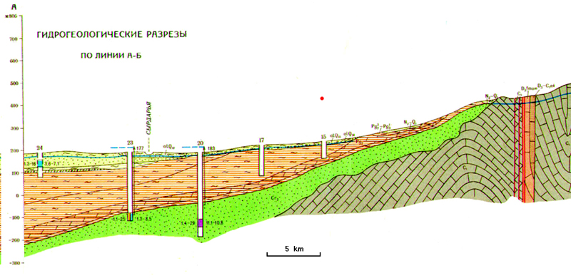
Figure 4 - Central part of TAM (zones 4.1-3, 5.1, 5.3, 6.1-2, 7.2), the most crowded of karez lines. / Lines of blue dots: karez lines / orange half circles: Saka kurgans / red square dots: Bronze and Iron Age settlements / yellow square dots: medieval villages of flat type / yellow circles: medieval villages of mound type / orange lines: walls of medieval town (Mirtobe)
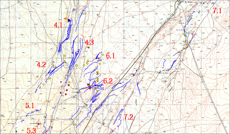
Figure 5 - Aero-photo of a k-system of parallel type (karez 7.3.1), made of 2 parallel karez lines and 1 canal. A more ancient karez line highly sedimented is visible few m right of it (view to NNE)
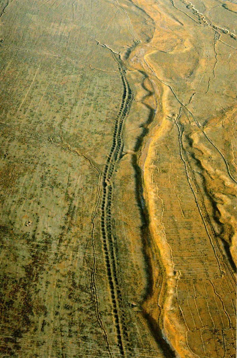
Figure 6 - Aero-photo of a k-system of intersecting type (central zone 6.2) (view to S-W)
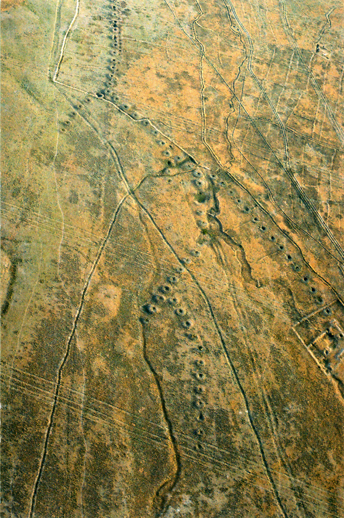
Figure 7 - Aero-photo of a k-line in zone 7.3, with few wells eroded by the Maidantal river (view to N)
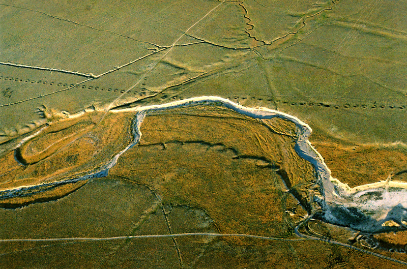
Figure 8 - Karez system of parallel type (K-system 5.2.1-8) reaching the northern part of the medieval town of Sauran (zone 5.2) (view to N)

Boldirev L.N. (1957). Zainaddin Vasifi.Tadjikskii pisatel XVI AC: opyt tvorcheskoi biographii (The XVI century Tajik writer Zainaddin Wasifi: an example of creative biography). Stalinabad (in Russian)
Deom J.M. and Sala R. (2006). 235 karizov regiona Sauran (The 235 karez of the Sauran region). In: Proceedings of the Conference 'Geografia Kazakstana: soderjanie, problemi, perspective; Published by Kasgu, April 2006 (in Russian)
Dingelshtedt N. (1889). Oput izucheniya irrigatsii Turkestanskogo kraya (An experience of study of the irrigation in the Turkestan region). Tome I-II. Saint Petersburg (in Russian)
General Direction of Geodesy and Cartography of SSSR (1956) Topographic maps, scale 1/100000 and 1/25000
Groshev V. A. (1985). Irrigatsia Youzhnogo Kazakhstana v srednie veka (Irrigation in South Kazakhstan during the Middle Ages). Alma-Ata (in Russian)
Institute of Aero-Geology (1977). Hydro-geological profile of the Turkestan Oblast, Map K-42-2. Moscow
Sala R. (2003). Groundwater galleries in Middle East and Central Asia.www.lgakz.org (in English and Russian)
 © The Author(s) -- Los artículos son propiedad de sus autores. (Ley 11.723 de la Republica Argentina)
|
|
 |

|