Transoxiana 13
Agosto 2008
Index 13
ISSN 1666-7050


|
Transoxiana 13  |
Institute of Archaeology, National Academy of Science of Kazakhstan
azret_sultan[@]mail.ru
Ruins of Sauran medieval fortress are situated in desert, 40 km to the north-west from Turkestan city (before the 17th c. – Yasy) (Kyzylorda region, Kazakhstan Republic). There are the most spectacular and well-preserved medieval ruins in Kazakhstan. Medieval Sauran city is regarded and described as a standalone city oval in shape and surrounded by fortified walls (Lerh 1870, 16-17; Heinz 1898; Code 1994, 308-310)1 in a comparatively good state of preservation in the literature on the subject from the time of its first archaeological survey. Near neighborhood with remnants of mediaeval agricultural and irrigation layout planning is supposed to be a vast farm district, the area of which is variously and approximately estimated. Until now in visual examination and particularly on the air photos we can clearly distinguish some household plots with enclosed rectangular gardens and vineyards, and a network of irrigation ditches and canals. As far back as the end of the 60-s as a result of decoding air photos of the city neighborhood, the traces of the kariz / kahrez, underground drainage galleries to supply ground water to the city (Akishev, Baipakov 1973, 76-78) were found.
Since P. Lerh the city of Mirtobe located at 6 km to the north (Code 1994, 307) was described as bearing relation to Sauran. The researchers believe that this small fortification located close to the dew mound2 and surrounded by garden-park was referred to as Mir-i Arab after the nickname applied to local sayyid Emir Abdallah, who according to Zeinatdine Wasifi was notable also for building and presenting two unique life-giving kariz3 to the city (Baipakov, Smagulov 2005, 74-77). Early history of Sauran is related to the city of Karatobe, located at 3 km south from a Late Medieval city with cultural layers dated back to the mid of the 1st millenium AD till the 13th c. (Code 1994, 307; Baipakov, Smagulov 2005, 62-65).
Thus, the history of the city of Sauran at the present level of knowledge is reasonably linked with a number of heterogeneous definitely localized archaeological monuments of various degree of complexity. Naturally each of them has its own distinct structure but all together they form an ensemble (complex), which characterizes such a phenomenon as a medieval city much better than analysis of each taken separately4. Therefore, summarizing the materials and observations while making their analysis, we may formulate and offer the concept of “Sauran archaeological complex”, which gives better, in-depth and comprehensive analysis of the mediaeval urban culture of Kazakhstan. From the above it follows that “Sauran archaeological complex” we should understand as an ensemble of diverse and heterogeneous archaeological sites related through time by historical fate and in the space by structure-forming relations and in general variously characterizing ongoing history of culture of a certain community in particular region.
Major structural elements of Sauran archaeological complex have already been surveyed, described, and localized on the ground. Since these archaeological monuments are of different type and also of diverse dimension, naturally, they require different approach and different exploratory and recording procedures. At the same time they bear different investigative capacity as well as inherent features of various aspects of the urban culture. Primarily Sauran is a city –fortress with an adjacent suburban zone and necropolis. The preliminary archaeological investigation of this monument (Baipakov 1999; Smagulov 2000, 100-109; Baipakov, Smagulov 2005, 81-83) has been conducted under the State program “Cultural heritage” involving a broad-scale examination of a number of remarkable architectural and archaeological monuments (mosques, madrasahs, khankahs, mansion houses, city gates). The purpose of the archaeological works performed was to lay the foundation of the city-museum (Baipakov and all. 2005, 304-307). The information available on the city provides reasonable details (Baipakov, Smagulov 2005, 67-69) therefore I will not dwell on its description. I would like to note only that the city of Sauran like any antique city has its own sophisticated inner structure reflecting the structure of the medieval city in its historical development.
At present standard of knowledge we may divide the city into the following large sections (Smagulov 2007, 126-134): 1. City proper (or fortress of Sauran) - an area inside the walls, which apparently has traditional residential districts with municipal network alternated by places with public buildings; 2. Zone of the medieval necropolis (city cemetery) with mosque - musalla to the east from the city walls and with walled plots of land khazira to the south-east, presumably with burials in open-air; 3. Zone of suburban villa construction in the neighborhood of the city. Further detailed study of the city topography may lead to highlighting other important zones of the city.
Definition, description, study of the structural components of the city is an indispensable condition of an archaeological investigation of the cities. In our case one of the paramount objectives was to define actual limits and give adequate description of the neighborhood area.
The second important and big city is the city of Karatobe. The reason for including this city into Sauran archaeological complex was based on the results of the study of historical geography of the region, particularly, the works on localization of medieval cities of Kazakhstan. As no any layers and remains dated back to the time prior to 13th-14th centuries were found at the bottom of the occupation layers of the city of Sauran, and the latter started to be mentioned in the documental records from the 10th century, an idea was verbalized in the mid of the last century that the antique Sauran was localized somewhere on the left bank of Syrdarya river (Ageeva, Patsevitch 1958, 109-110). That is to say, the city changed its location during its centuries-old history. (It is quite common phenomenon in history of cities in general and in Central Asia – so much the more). Later it was assumed that pre-Mongol Sauran was located in the place of the city of Meiramtobe, which had original topography with multiple-row ring-walls (Baypakov 1986, 27). And only more detailed historical topography allowed to have early Sauran localized in the area of the city of Karatobe adjacent to the late Sauran (Code 1994, 307; Baypakov 1998, 65-70). Preliminary archaeological investigations of the city dated its upper occupation layer, which means upper limit of the period of vigorous growth of the urban life to the 12th-13th centuries (Baypakov, Smagulov 2005, 62-67). This dating should be clarified after big archaeological researches. The dating is in direct sequencing coincidence with dating of the lower layers inside the walls of Sauran. And discovery of the burial ground under the initial constructions horizon of late Sauran was the reason for the hypothesis of moving the new city to the place of the old city cemetery (Smagulov, Tuyakbaev, Erzhigitova 2000). So we may speak of a chronological and territorial continuity that in its turn strengthens an opinion that early city of Sauran was located in the area of the city of Karatobe.
A visual topographic survey of the land environment and the analysis of the available now detailed Karatobe air photography make it possible to represent this site as a rather sophisticated and interesting monument of urban culture. Its topography can be described as three confined by walls spaces almost strictly concentrically inscribed in each other (Fig. 1).
The broken perimeter of the external walls delineates almost a regular circle of 1900-2000 m in diameter covering about 3 km2. Here and there the wall is straight, in some places forming a right angle or an arch of a circle. The wall is badly identified on the ground, but can be rather easily interpreted on the aerial photos taken under side illumination. As if no regular bastilles along the perimeter of this wall come under notice. But in some places the wall is at right angle, which is not related to the surface relief. Apparently they used a special fortification technique, ensuring flank security of the most critical sections of the wall with an upper firing gallery on top of the parapet weathering. From the ancient times in the theory of fortification building there is a well-known technique of wall construction in the shape of meander line or crown. Central Asian version of implementation of this technique, in the opinion of experts, is found in the construction of the antique southern city wall of Pendjikent (Belenitski, Bentovitch, Bol’shakov 1973, 20; Semenov 1990, 60).
The territory inside the external ring of the walls only in some places is densely built-up, especially in the western part. The occupation layer, the existence of which is identified by a completely built-up area of yellow color occupies approximately one fourth of the total internal area. The remaining area most probably had no urban development. Judging by meandering channels there were two small rivulets running through this area from the north. The western rivulet had branching channel network (may be artificial). The city proper with completely built-up area was located in the center of this area between the meander beds (Fig. 2). This square shape area is approximately 0,3 sq. km with corners referring to cardinal points and lateral length of about 550 m. Right angle of this area is clearly identified in north-west corner. To date the other angular parts of this area turned out to be blunt and deformed by land leveling for the late fields as well as aryk beds. It seems that the southern and eastern parts of the completely built-up area in a state of fair preservation initially were parallel to northern and western parts.
In the center of this area there is a citadel of rough oval shape with a straight wall in the south. The area of the citadel of 340 х 280 m is rising above the ground level for about 6-8 m. Microtopography clearly identifies “swelled out” rectangle of 130 х 115 m in area right in the central part of this hill. The highest point of the whole city forming a massive hill is located in its south-eastern part. Triangular pillar was here until recently.
Thus, at present we may reconstruct three rows of concentric city walls (defense lines) in the city of Karatobe. The first (outside) wall enclosing the area of 3 km2 was about three kilometers long. The curved line of this wall stands out particularly. It can be believed that the curved outline was purposefully made to give the walls increased fortification properties. The inner city of almost square shape was inside the wall of 2200 m long. The citadel oval in shape in the center of the square was surrounded by the wall of approximately 1000 m in length.
As it was mentioned above, the upper limit of busy urban life in Karatobe is dated back to the 12th c. (beg. of the 13th c.?) (Baipakov, Smagulov 2005, 62-67). This implies that topography of the city described above characterizes the city of the Samanid and Karakhanid eras in the 9th-10th cc., when urban life in South Kazakhstan reached its fullest flourishing, the time of rapid growth of the and sedentary culture in the region on the whole (Belenitski, Bentovitch, Bol’shakov, 1973, 195)5. The above-mentioned natural features witness to the fact that the city was founded and initially built in accordance to the strict city-building and architectural design. Its preliminary topographic and architectonic description (concentric zoning, fortification reasoning, water situation, etc.) testifies to a high-level city-building art. Considering the fact that the old city has been slightly affected by the latest agricultural activity and its upper occupation layers of the 10th -11th centuries have not been overlaid by later occupation layer, it must be admitted that this monument deserves long-term integrated investigation and, what is very important, conservation.
A unique monument of country landscape gardening for the medieval culture of Kazakhstan is Mirtobe, the next element of Sauran architectural complex. Usually this monument is described as a square shaped fortification with lateral length of approximately 70 m and height of the walls of up to 5-6 m with some land leveling and remains of habitation in its vicinity (Code 1994, 307). This area as maybe reasonably assumed was described by the well-known author of the beginning of the 16th century Zeinetdin Wasifi (Boldyrev 1957) quoted on more than one occasion. It must be noted that the information given by him on the whole is confirmed by the ground map. Moreover, the analysis of detailed aerial photos made it possible to adjust and update them. In addition to the square shape proper fortification of Mirtobe we may clearly distinguish one more of similar dimensions square located to the east from it (Fig. 3). Probably, here we have strongly swollen ruins of an elder fortification, which under Mir-Arab was not restored; they just built a new one nearby.
As far as charbag (a landscaped garden-park) is concerned, it may correspond to the walled-in territory around the fortress (at the first stage) or most likely the other layout design fenced about with straight walls and towers at a regular distance. The area of the enclosure is approximately 300 х 1200 m. The traces of this layout design are clearly seen on the aerial photos taken at a distance of 150 m to north-east from the fortress6. This layout design was actually built on the kariz lines and in some way (so far not clear how) connected with them. Inside its walls there was a pool, as well as ruins of some construction, which corresponds to the service space described by Wasifi.
The line of another kariz is found outside the walls. The interior space has a proper comb planning peculiar to the traces of vineyards and there is a depression of square shape of 35х30 m in area in the center of the territory, where it is supposed to be the ruins of the dew mound mentioned by Wasifi, which was a special underground domed facility for underground water catchment and storage.
On the basis of detailing agricultural and irrigation layout planning in the area of Mirtobe and to the north from Sauran it was recorded that Sauran and Mirtobe karizes structurally are not connected with each other and represent different systems. They even use various underground water resources and consist of two different kariz systems located in various zones (Deom, Sala 2005, 120-132). So far we didn’t find any confirmation of the assertion by Wasifi that the source of kariz built by Mir-i Arab and supplying water to the city of Sauran was located near Mirtobe, as well as other information concerning the dimensions of “Mir-i Arab karizes”(Smagulov 2003, 172-190; Baipakov, Smagulov 2005, 73-80).
Availability of the kariz water supply system in the city attaches an additional unique character to the Sauran archaeological complex. For the first time the traces of karizes built on the funds of the local religious and financial magnate Mir-Arab have been discovered as mentioned above while making the analysis of the aerial photos taken in the vicinity of the city of Sauran as far back as the end of the 60-s of last century (Akishev, Baipakov 1973, 76-78). In 1986-88 V.A. Groshev as a member of the South Kazakhstan Integrated Archaeological Expedition started field works with the purpose of archaeological study of karizes of Sauran. He discovered 3 lines of karizes and on the basis of the acquired data, he assumed that all the 3 lines could be a part of one and the same very large system, which we recommended to be called “Grand Sauran kariz” and mentioned by Wasifi with its source located in the area of the medieval fortress of Mirtobe (Fig. 4). The report details the work on a dig in 2 wells of the first line of karizes up to the depth of 4 m, though the area shows the traces of the work on the dig in 11 wells, as a result of which no traces of any underground drainage gallery have been discovered (Groshev 1996, 184-186).
Thus, it became clear that application of only archaeological methods in the study of this type of medieval water-work monuments is apparently insufficient. A long-felt need was to use other methods and practices of registry, description and investigation of this phenomenon. We were fortunate to acquire new material upon using conventionally named “geological and archaeological” approach in exploration, registry and recordkeeping (Smagulov 2003, 172-190). The applied practice made it possible to identify, document and map the traces of 235 karizes (in fact far more) of different length in the area of the medieval Sauran. If we assume that under ring-type network found on the surface there are underground drainage galleries and take measurements then the total length of them will make over 110 km.
This is established that the medieval city of Sauran was located in the lower delta zone of three former mountain streams – the Tastaksay, the Aksay and the Maidantal, flowed from the southern slopes of the Karatau mountains in the direction of the Syrdarya river. In the middle and lower reaches they had multiple parallel, deviating and converging streamflow separations. Combined they constitute three talus trains converging all together in desert, in the area of the antique cities of Karatobe and Sauran, where their surface and underground waters mingle (Deom, Sala 2005). The Maidantal river consists of the largest surface and underground water flows and actually the area where it runs is the major hydrologic basin; the Aksay river flow is not so strong, but since it runs in the central lower-lying ground, it has middle and lower reaches of the river bed, which is fed by water in the place of junction of underground waters of other 2 streams. Except for the principal canyon of the rivers Tastaksay and Maidantal and lower reaches of the river Aksay, which have although poor but year round perennial streams, all the others are intermittent streams flowing only in spring.
A remarkable concentration of the traces of underground drainage galleries have been discovered along these riverbeds (description of the well-identified kariz traces in the area see for example in: Akishev, Baipakov 1973, 76-78; Smagulov 2003). It is proven by documentary evidence that two Sauran karizes mentioned in the work of Wasifi “Amazing events…” by no means were unique and ever yet seen constructions. Underground drainage galleries were built not only for water supply in the city, but also to water the fields, i.e. for the purpose of irrigation and they appeared here well before those underground drainage galleries, which were built by Mir-Arab. In the environment of local arid Central Asian climate arable farming and settlements could not be based only on the mountain stream flows, which were fed mainly by flood and spring waters. As a rule there was an acute water shortage in summer in such hot-arid zone. In order to meet this deficit and set a reliable water base for agriculture these underground drainage galleries were built, which utilized favorable local hydrological environment and secured stable life-giving water supply to the crop areas and settlements.
Thus, we have established as a fact and documented enduring tradition of active usage of underground waters for the purpose of water supply to the cities (Sauran, Turkestan) and irrigation of the fields, gardens in the Middle Ages. Now the problem arises to determine the age of appearance of the underground drainage galleries in the region and their design surveillance. In view of the importance of water resources in the local extremely arid environment we may consider the Sauran kariz water supply and irrigation system to be one of the most important elements of the archaeological complex. There is little information about karizes in the Medieval Arab and Persian written sources, though in the description of any city of Central Asia or Khurasan they usually mentioned of water resources thanks to which one or another city or large settlement lived. It is characteristic that in the fundamental review made by V.V. Bartol’d he mentioned only karizes of Merv, Ferava and Sauran (Bartol’d 1965, 130, 138, 225). Direct kariz water (in point of fact – spring water) use value has been recognized by contemporary environmental specialists (Tursunov 2002). And it is well known that it was specially worshipped in the traditional culture of Central Asia. This water was treated as a “sacred gift” both by rural, nomadic, semi-nomadic people and people living in big cities. For example, people of Samarkand until recently adhered to the common perception of miraculous medicinal property of the Obirakhmat and Obimakhshat channel waters. These channels are fed by underground spring waters (karasu) (Isamiddinov 2002, 16).
The kariz system in addition to utilizing seasonal surface waters through togans and aryks clearly defined in the micro-topography of the area, ensured functioning of the vast agricultural zone situated in the basin of the above-mentioned rivers and in the vicinity of the city of Sauran. The traces of the medieval agricultural and irrigation layout design is well defined on the surface and little impaired by the latest activities. The zone of its spread covers and combines the above-mentioned and other elements of Sauran archaeological complex. On the whole this monument of the developed agricultural region of Sauran embodies a well-known theoretical opinion into a practical conclusion of agricultural character of Central Asian cities in distinction from West European. As we see the systematic generalization of archaeological, historical, topographic data leads to somewhat different from conventional understanding of the archaeological monument, which remained on the place of one of the most famous mediaeval cities of Kazakhstan, which is deemed to be historical Sauran, or more specifically a vast space in the middle and lower reaches of the Tastaksay-Maidantal interfluvial plain with well preserved archaeological traces of various elements of urban structure. It is not a new approach in the archaeological science and it is applied wherever a medieval city is described as “an archaeological complex” with a necropolis or a suburban zone with various elements of marginal development or with traces of agricultural development. The unique character of Sauran monument is that all the principal elements of its archaeological complex still remain in a satisfactory undamaged condition and easily accessible for investigation. These adjacent elements (of the structure) were located in the same area and more often overlapped each other. When we realized the fact that the archaeological monument of Sauran was a complex of diverse monuments having a vast zone of spread we had to view the matter of its conservation in a different way. The area of Sauran archaeological complex according to preliminary estimates covers approximately 30-35 km2 stretching from north-east to south-west (Fig. 5). In the lower southern section from NW to SE it is crossed by a highway and a railway with corresponding waysides from NW to SE. A flagrant necessity at present is to ensure state protection not only of some monuments (fortress of Sauran, Karatobe, etc. with a 50-meter protection belt according to the “Monuments’ Conservation Act”) but also the zone (territory) of their spread as an archaeological conservation area with relevant planning of land use granting an adequate status (Act of the Republic of Kazakhstan “On Conservation and Usage of the Historical and Cultural Heritage”, Articles 36 and 37).
Ageeva E.I., Patsevitch G.I., 1958. On the History of the Sedentary Settlements of South Kazakhstan (Iz istorii osedlykh poselenii i gorodov Yuzhnogo Kazakhstana) – Transactions of the Institute of History, Archaeology and Ethnography of the Academy of Sciences of Kazakh Soviet Socialist Republic (Trudy Insituta istorii, arkheologii i etnografii Akademii Nauk Kazkh SSR), Vol. 5. Alma-Ata.
Akishev K.A., Baipakov K.M., 1973. Karizes of Sauran (Kyarizy Saurana) – Academy of Science of Kazakh Soviet Socialist Republic Herald (Vestnik Akademii nauk KazSSR), 1973/4.
Babajanov B., 1995. Mir-i Arab – Culture of Nomads on the Turn of Centuries (the 19th-20th, the 20th-21st cc.) Problems of Genesis and Transformation. The Proceedings of the International Conference (Kul’tura kochevnikov na rubezhe vekov [XIX-XX, XX-ХХI vv.]. Problemy genezisa i transformatsii. Materialy mezhdunarodnoy konferentsii). Almaty.
Baipakov K.M., 1986. Medieval City Culture of South Kazakhstan and Jetysu (the 6th –the beg. of the 13th cc.) Srednevekovaya gorodskaya kul’tura Yuzhnogo Kazakhstana i Semirech’ya (VI – nachalo XIII vv.). Alma-Ata.
Baipakov K.M., 1998. Medieval Cities of Kazakhstan in the Great Silk Road (Srednevekovye goroda Kazakhstana na Velikom Shelkovom puti). Almaty.
Baipakov K.M., 1999. Medieval Sauran (Srednevekovyi Sauran) – Cities of Turkestan (Goroda Turkestana). Almaty.
Baipakov K.M., Smagulov E.A., 2005. Medieval City Sauran (Srednevekovy gorod Sauran). Almaty, 2005.
Baipakov K., Smagulov E., Erzhigitova A., Tuyakbaev M., Toleev D., Beysebaev A., Zheleznyakov B., 2005. Excavations of the Fortress of Medieval Sauran (Issledovaniya gorodishcha srednevekovogo Saurana) – Cultural Heritage of Kazakhstan: Discoveries, Problems, Perspectives. The Proceedings of the International Conference (Memlekettik “Madeni myra” bagarlamasy bojinsha 2005 zhylgy Archeologiyalyk zertteuler zhayly esep). Almaty.
Bartol’d V.V., 1965. On History of the Irrigation of Turkestan (K istorii orosheniya Turkestana). – Selected Works (Sochineniya), Vol. III. Moscow.
Belenitski A.M., Bentovitch I.B., Bol’shakov O.G., 1973. Medieval City of Transoxiana. (Srednevekovyi gorod Sredney Azii). Leningrad.
Boldyrev A.N., 1957. Zainatdin Vasifi – Tajik Writer of the 16th c. (Zainatdin Vasifi – tajikskii pisatel’ XVI v.). Moscow.
Brey W., Tramp D., 1990. Archaeological Dictionary (Archaeologicheskii slovar’). Moscow. Code of Monuments of the History and Culture of Kazakhstan. South Kazakhstan Region (Svod pamyatnikov istorii i kul’tury Kazakhstana. Yuzhno-Kazakhstanskaya oblast’) (Ed. by K.M. Baipakov). Almaty, 1994.
Deom J.M., Sala R., 2005. The 232 Karez of the Sauran region – Conservation and Usage of the Objects of Cultural and Mixed Heritage in Modern Central Asia (Sokhranenie i ispol’zovanie kul’turnogo i smeshannogo naslediya sovremennoy Tsentral’noy Azii). Almaty.
Groshev V.A., 1996. Ancient Irrigation of South Kazakhstan (Drevnyaya irrigatsiya Yuzhnogo Kazakhstana). Almaty.
Heinz A.K., 1898. Travel to Turkestan. Diary of the 1866 (Puteshestvie v Turkestan. Dnevnik 1866 g.) - Selected Works (Sochineniya). Vol. 2. St.-Petersburg.
Isamiddinov M.H., 2002. Origin of the City Culture of Samarkand’ Sogd (Istoki gorodskoy kul’tury Samarkandskogo Sogda). Tashkent.
Juraeva G.A., 1985. Mir-i Arab and the Political Life in Bukhara in the 16th c. (Mir-i Arab i politicheskaya zhizn’ v Bukhare v XVI v.) – Priesthood and the Political Life in the Near and Middle East in Feudalism Period (Dukhovenstvo i politicheskaya zhizn’ na Blizhnem i Srednem Vostoke v period feodalizma). Moscow.
Klyashtorny S.G., 2003. History of Central Asia and the Monuments of Runic Written Language (Istoriya Tsentral’noy Azii i pamyatniki runitcheskogo pis’ma). St.-Petersburg. Lerh P., 1870. Archaeological Trip in Turkestan Region in 1867 (Arkheologicheskaya poezdka v Turkestanskiy kray v 1867 g.). Vol. VIII. St.-Pertersbug.
Materials on the History of Tirkmenians and Turkmenia, 1939. Vol. 1. 7th-15th cc. (Ed. by S.L. Volin, A.A. Romaskevitch, A.Ya. Yakubovsky). Moscow, Leningrad.
Ptitsyn G.V. 1947. On the Problem of “Shah-nama” Geography (K voprosu o geografii “Shah-name”) - Transactions of the East Department of State Hermitage (Trudy Otdela Vostoka Gosudarstvennogo Ermitazha). Vol. IV. Leningrad.
Semenov G.L. 1990. City and Castle in Early Medieval Sogd (Gorod i zamok v rannesrednevekovom Sogde) – Cultural Contacts of Peoples of Transoxiana and Caucasus. Antiquity and the Middle Ages (Kul’turnye svyazi narodov Sredney Azii i Kavkaza. Drevnost’ i srednevekov’e) (Ed. by B.A. Litvinski). Moscow.
Smagulov E.A., 2000. Sauran City (Perspectives of Study, Conservation and Museefication (Gorod Sauran [perspektivy issledovaniya, konservatsii i muzeefikatsii]) – Native History (Otan tarihy), 2000/1-2. Almaty.
Smagulov, Tuyakbaev, Erzhigitova 2000. Mane Results of the Excavations of Turkestan Archaeological Expedition (Kratkie itogi issledovanii Turkestanskoy arkheologicheskoy expeditsii) - Proceedings of the Ministry of Education and Science, National Academy of Sciences of Kazakhstan Republic (Izvestiya Ministerstva obrazovaniya i nauki, Natsional’noy Akademii Nauk Respubliki Kazakhstan). Social Sciences. 2000/1.
Smagulov E.A., 2003. Karizes of Turkestan Oasis (Kyarizy Turkestanskogo oazisa) - Proceedings of the Ministry of Education and Science, National Academy of Sciences of Kazakhstan Republic (Izvestiya Ministerstva obrazovaniya i nauki, Natsional’noy Akademii Nauk Respubliki Kazakhstan). Social Sciences. 2003/1.
Smagulov E.A., 2007. Sauran Archaeological Complex: Definition, Composition, Limits (Sauranskii arkheologicheskii complex [definitsiya, sodarzhanie, granitsy]) - Proceedings of the National Academy of Sciences of Kazakhstan (Izvestiya Natsional’noy Akademii Nauk Respubliki Kazakhstan). Social Sciences. 2007/1. Alma-Ata.
Tursunov A.A., 2002. From Aral Sea to Lop-Nor. Water-ecology of Non-Flowing Basins of the Central Asia (Ot Arala do Lobnora. Gidroecologiya besstochnykh basseynov Tsentral’noy Azii). Almaty.
Fig. 1. Three parts of Karatobe medieval city (Early Sauran): citadel, shahristan, ribad. The distant object – Sauran medieval city. Air photo (2006). 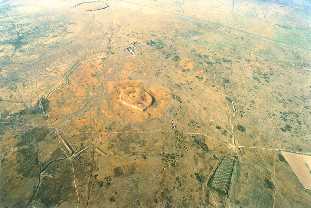
Fig. 2. Air photo of citadel and shahristan of the medieval city Karatobe (Early Sauran) (2006).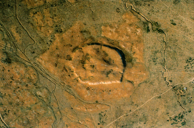
Fig. 3. Air photo of Mirtobe (2006).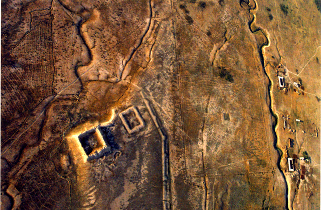
Fig. 4. Lower section of the Big Sauran kariz. Air photo (2006). 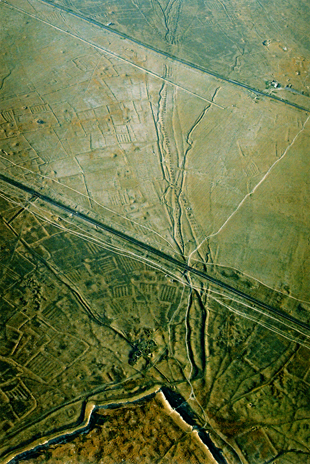
Fig. 5. Sketch map of the prospective Sauran archaeological reservation area (from upper to lower: Mirtobe, Sauran, Karatobe).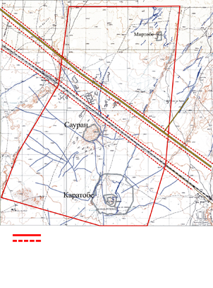
1 . P. Lerh having surveyed the city, worked «on a small dig inside the fortress, domineering for 7 Russian fathoms above the ground surface” (Lerh 1870, 12-15).
2 . According to P. Lerh “serdabe” is an underground water reservoir, covered by a cupola (Lerh 1870, 14). The “dew mound” structure is a standard practice of the development of and water supply to the cities of Central Asia, Khurasan, Middle East.
3 . Mir-i Arab or Abdallah al-Iamani al-Hadramauti, also known as the “builder” of medrese in Registan of Bukhara named after him – Mir-i Arab medrese (see about him: Babjanov 1995, 88-102; Juraeva 1985, 74-79).
4 . The term "complex" is widely used in a conceptual field of archeology in description of the events of various scopes and various degree of complexity (from “archeological complex of culture”, up to “archeological complex of burial”). It is a common practice to distinguish closed and open archeological complexes. “If two or more items are found together and it is possible to prove, that they have happened to be in the same place at the same time, they shall be deemed to be in a true or closed Complex. In case with open complex the contemporativity is only assumed, but not proven. No attention shall be paid to accidental coincidence. Significance of any find increases owing to being in a complex with other items, which can help with its interpretation, dating, establishing cultural relations, purposes, etc." (Brey, Tramp 1990, 117). The latter, i.e. package treatment of the artifacts is relevant to the situation under consideration.
5 . Reference by Makdisi (10th c.) to «seven walls of Sauran» allegedly encircling the city (Materials 1939, 185), is probably a mythological literary expression, an idiosyncratic cliche to emphasize the strength of fortified structures of the city. There is sacred number seven in the description of inexpugnable walls made of various metals and surrounding Kangdiz in “Shah-name”. Compare with the legendary capital of Tur tribe, a mythological unassailable fortress built by Siyavush in Kangh in remote eastern outskirts of Iranian land, where immortal Pishyotan ruled behind seven walls (Ptitsyn 1947, 305; Klyashtorny, 2003, 213-216).
6 . In this article we used the air photos and other materials of R. Sala and J.M. Deom. I take this opportunity of thanking them for their contribution in joint work.
Dr. Erbulat A. Smagulov,
Institute of Archaeology, National Academy of Science of Kazakhstan,
Almaty, Kazakhstan.
e-mail: azret_sultan@mail.ru
Address: Dr. Erbulat A. Smagulov, Institute of Archaeology, 44, Dostyk av., Almaty, 050028, Kazakhstan.
 © The Author(s) -- Los artículos son propiedad de sus autores. (Ley 11.723 de la Republica Argentina)